
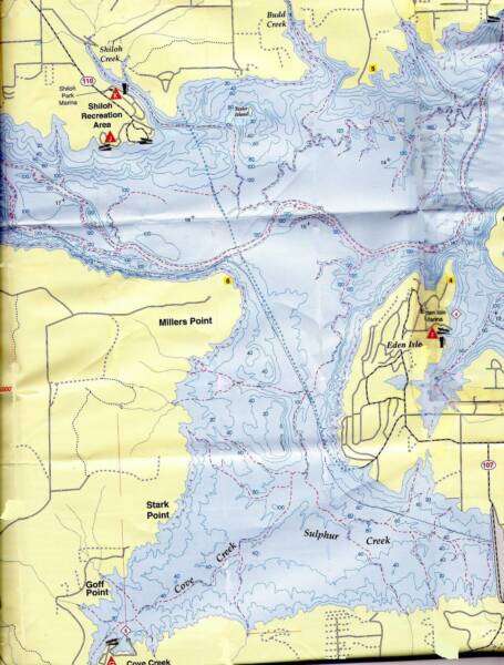
This section of the lake is easily accessible from the Shiloh and Cove Creek Boat Launches
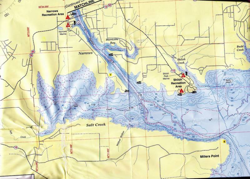
This section of the lake is easily accessible from the Shiloh and Narrows Boat Launches
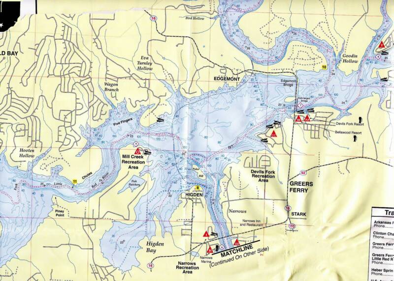
This section of the lake is easily accessible from the Mill Creek, Narrows and Devills Fork Boat Launches
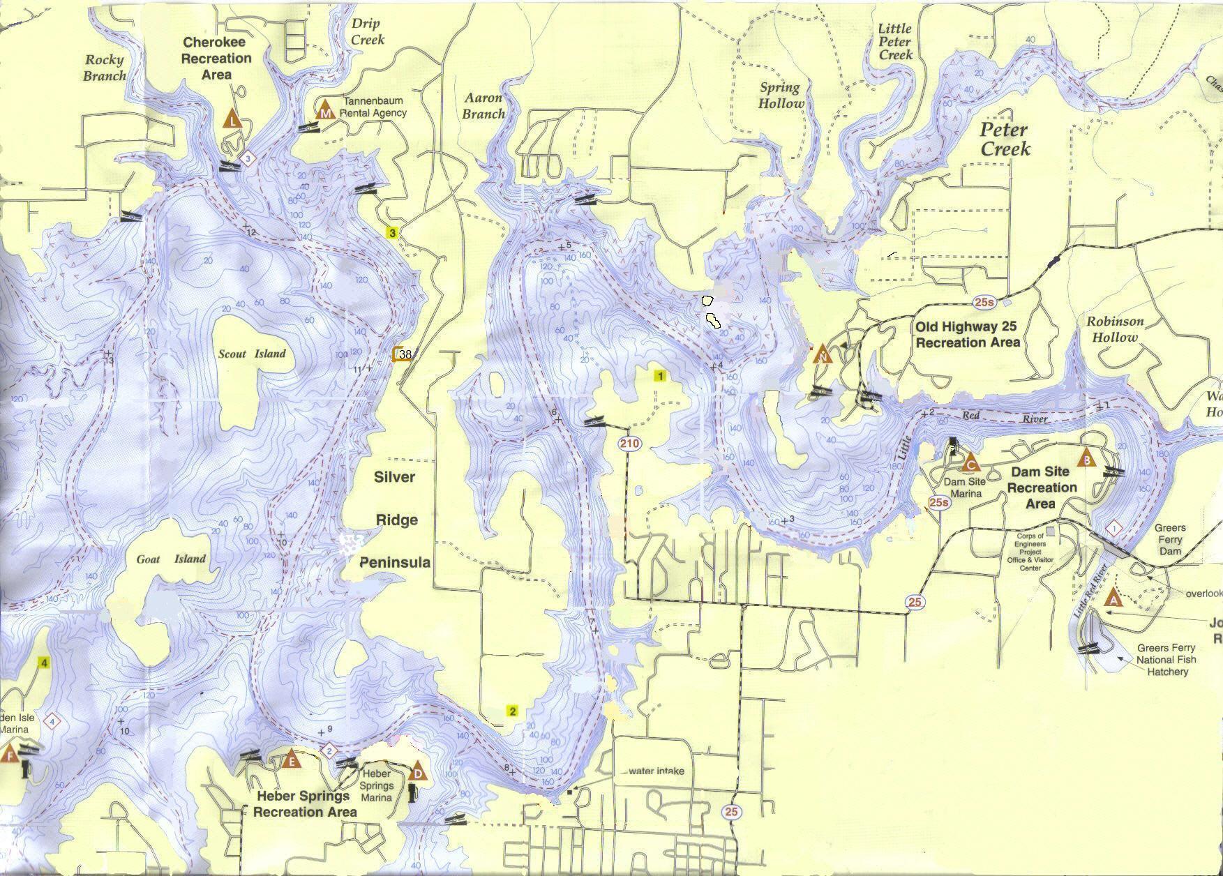
Greers Ferry Dive Sites Site D 0.5 Dam long site UTM GRD Rt 0591700 Up 3931500 N 35 o 31' 480" W 91o 59' 318" This site is long, if you go from the north end all the way to as close as you can get to the Dam it can be over 500 yards. Not much there for heart pounding excitement but twenty feet and less is good spear fishing. I took one large Bass and saw a very large Cat maybe 14 - 18 lbs. If you go deeper than sixty feet there are a lot of trees. Nearest launch site: Dam Site Rec Area.Best time of day: any time this site gets sun all day
Site D1 Robinson Hollow Cliff UTM GRD Rt 0591521 Up 3932344 N 35 o 31' 937" W 91o 59' 430" This site is not as good as I had hoped it would be. It is OK. There was a couple of caves at 40 and 33 foot range. One was big enough for some brave soul to go in but not me. There was a small wall on the southern half. that went from the 40 to 25 foot range. There were some nice rock formations at 25 feet and up. This site is about three hundred yards or so long.Nearest launch site: Dam Site Rec Area.Best time of day: any time this site gets sun all day
Site D2 Rope Slide UTM GRD Rt 0590780 Up 3932100N 35o 31' 809" W 91o 59' 922" This site looks a lot better out of the water. I did not like this one because there was not much to see, but I did shoot a very nice Large Mouth Bass, about four lbs. Nearest launch site: Dam Site Rec Area.Best time of day: Morning to Mid Day
Site 1. Cabin Cruiser UTM GRD Rt 0590842 Up 3932566. N 35o 32' 061" W 91o 59' 878" A 33 foot cabin cruisers at 35 Feet, Access is by boat , big or small is OK. Lots of trees and a few fish but a good dive even after the sunken boat. Clear water at times. You can drive to this site, there is no parking nearby, but; if you have someone to stay with your car you can drive to it. If you want to drive to and walk into this site it is easy. From the Dam take Hwy 25's just like you are going to the Old Hwy 25 Rec. Go all the way to the Rec. Area entrance then turn around and come back and take the second pavement road on the right then look for the boat launch. From the boat launch it is about fifty or sixty yards to the left, or north, then abut another thirty-five or forty yard away from shore, east.Nearest launch site: Dam Site Rec Area.Best time of day: any time this site gets sun all day
Site 1.9 Marina Cove UTM GRD Rt 0590100 Up 3932400.N 35o 31' 975" W 92o 00' 370" This is a very easy dive. Not much as far as rock formations or even trees. It is a clean gentle sloping bottom and you can go as deep or shallow as you want. The only thing that made it a good dive for me was the school of stripers that followed me around. You may not see them but it is exciting if you do. There were a lot of them, some four or five pounders and they kept coming back to see what I was up to. Nearest launch site: Dam Site Rec Area.Best time of day: any time this site gets sun all day
Site 2 Old Hwy. 25 Wall UTM GRD Rt 0589800 Up 3932340. N 35o 31' 945" W 92o 00' 569" This is a good site straight across from the Dam site Marina. A RE-DO anytime. A good wall with a good amount of fish. Up close to the surface there are some nice looking caves and crevices for fish to hide in and they were fun to find. This site is a boat access, or a drive to and walk in. A small 14 fishing boat is fine, a very nice shore dive you can step up to the water edge and giant stride off into clear deep water or you can wade in if you prefer A very nice shore entrance. Big boat is OK as well. There is a nice cove to anchor in.If you want to drive to and walk into this site it is easy. From the Dam take Hwy 25s just like you are going to the Old Hwy 25 Rec. area but don’t turn into the rec area and the road will dead end in the Lake. There is parking there. You would unload your gear at the waters edge then park about fifty yards away. Then carrying your gear, or as I do wear it, walk around the point to the left, or East until you get to the bay/ cove and then a short swim of about a hundred yard or so and you are there. Now if you were studying you map you would have noticed you walked through site # 3 so you may want to dive it as well while you are there. This is a long walk but worth it.Nearest launch site: Old Highway 25 Rec AreaBest time of day: Just about any time.
Site 3. Christmas Tree Habitat UTM GRD Rt 0589450 Up 3932320N 35o 01' 936" W 92o 00' 801" This was a very cool dive site. There were some Christmas trees that had been placed here for the fish, I did not see as many fish as I thought I would. However this was still a good dive. There were some trees but they were scared well enough to not be a burden, in fact that is one of the things that made it look good. There were some big rocks, or boulders, to play around, there was a deep, very deep, wall and some ruins of a boat dock. A pleasant re-do dive. If you want to drive to and walk into this site it is easy. If you are coming from the south just go over the Dam and take Hwy 25s just like you are going to the Old Hwy 25 Rec. area but don’t turn into the rec area and the road will dead end in the Lake. There is parking there. You would unload your gear at the waters edge then park about fifty yards away. Then carrying your gear, or as I do wear it, walk to the point to the left, or East and start your dive there and going left, or East.Nearest launch site: Old Highway 25 but Dam site is just as close. Best time of day: just about any time
Site 4. Old HWY 25 Swimming Area UTM GRD Rt 0589800 Up 3932340. N 35o 31' 945" W 92o 00' 569" This is should be a winter only dive site. In the Park it is in Area “A”. In the middle of the swimming area go out through the swimming area until you get the depth you want. I went about sixty five feet which was about thirty yards out of the swimming area. There were some nice tall rock formations to play around with good looking over hangs as well. Just be aware there are two boat launches one on each side, therefore, this is a better winter dive then summer because of boat traffic and you will be in their channel approach lanes I dove it both winter and summer without any problems. In fact I have dove this a lot in winter I have been over one hundred feet here. You are not suppose to dive swimming areas but no one ever said anything to me just be courteous to others.Best time of day: just about any time
Site 5. Swimming Cliffs
UTM GRD Rt 0589550 Up 3931980. N 35o 31' 751" W 92o 00' 737" This is the dam site swimming area next to the Marina. Good area for swimmers and divers. There are cliffs for swimmers to dive off and is also a great night dive - just watch out for the cliff divers. Although it is a very long walk to the water, it is an easy walk on pavement. The best entry and exit are to go all the way out to the end, past the swimming cliffs to enter, then come around to the swimming cliffs and go back to entry point before resurfacing. There is also a good site just south of this area that you can swim to, GRD Rt 8950 Up 3150. A long swim, about 450 yards, but a lot of fun and in a cove. Later in the summer visibility may be a problem, but was not a problem when I went in early April. I heard someone had a problem with the Park Rangers while diving there but I never have. Just take a dive flag and be nice.Suggested time of Day for most light and best visibility.: Mid day and after.Nearest launch site: Dam Site Park
Site 6. Twin Falls East UTM GRD Rt 0589500 Up 3931500. N 35o 31' 492" W 92o 00' 773" Cove next to swimming cliffs at Dam site, this is a good dive site and a redo. Saw lots of fish including cat fish. Best dive time is around noon so you can get sun light. You can swim there but I would use a boat as it is a long swim. Big or little boat is OK. Nearest launch site: Dam Site Rec Area.Best time of day: Mid day
Site 7. Twin Falls West
UTM GRD Rt 0589500 Up 3931300. N 35o 31' 384" W 92o 00' 775" This is an OK dive. Not a lot of big rocks or cliffs as you might think but there was some fish and there are trees in the deep part. The shallow was fairly clean.Nearest launch site: Dam Site Rec Area.Best time of day: Mid day
Site 8. Tree top Cliff
UTM GRD Rt 0589400 Up 3931340. N 35o 31' 406" W 92o 00' 341" This site is next to the dive cliffs. I really started at the point and went southwest There is plenty of depth if you want it. There are a lot of down trees and some standing. No real wall as such, but some drop offs and all the depth you can use, 160 feet. It was interesting enough to do again. There may have been a wall but I only went to 64 feet and never really saw it. So you real deep divers go for it.Nearest launch site Dam siteBest time of day: any time before late afternoon.
Site 9. Rock Slide
UTM GRD Rt 0588500 Up 3931140N 35o 31' 303" W 92o 01' 437" OK, This is one of those sites that I am not saying to do I am just telling you I did and this is what I saw. There were a lot of down trees, it looked a little like it had been clear cur and everything was left. Not a pretty site in fact it could be dangerous. Plus what was not covered in down trees looked like a giant rock slide but all small rocks. Not very inviting. There were some big rocks and a couple of cliffs but all in all I don’t think was all that great and I want do this one again. Unless some one really wants me to.Nearest launch site Dam site. Best time of day: any time before late afternoon.
Site 9.9 Island Trainer UTM GRD 0588500 UP 3931750N 35o 31' 632" W 92o 01' 400" This is a clear dive. No trees, rocks or anything else, but it will make a great training area as it is close to the main channel and has lots of roomNearest launch site: Old Hwy. 25 Rec Area.Best time of day: any time before late afternoon
Site 10. Miller Mansion UTM GRD Rt 0588050 Up 3931450 N 35o 31' 473" W 92o 01' 733" Miller's Mansion This is a good cliff dive. The visibility the day I was there was not great but that is not always true as this place has some depth. If you drop a dive flag, have a lot of rope or line on it as the depth is about 160 up close to the cliff. This is a site where boat access is best. I used a flat bottom fishing boat and pulled it up on the rocks - no problem at all. A big boat is fine. You can drive to it but there is NO Parking close by. You need to drop off your gear leaving someone with it as you look for a place to park. Good luck with that. There are a lot of beer and soda cans and some 55 Gal barrels and a bunch of fallen trees. There are also some big crevices. I only saw one cave but that doesn't mean there are not more, as I only dove it once. The cave I did see had a floor entrance, meaning it came into the cave through it’s ceiling, not a wall type, made it look interesting, but I don't do caves. Nearest launch site: Old Hwy. 25 Rec Area.Best time of day: any time before late afternoon
Site 11 Channel Wall From Rt 0587800 Up 3931900 to Rt 0587850 Up 3931770N 35o 31' 473" W 92o 01' 733" This site was a neat little Wall dive. Not real shear but still a nice one. It is a little more in the channel than most would want but if you are up to the challenge of diving near a lot of boat traffic it is worth the effort. I use at least three flags and suggest you use that many or more just to let everyone know you are there and never surface in the channel you have to come back to the shore. There were some trees both down and standing but not enough to be a problem. The wall is a little deep in fact not much of a dive for twenty five and up. But depth is good the wall went deep I stopped at 70 feet. A good enough of a dive for me to take someone to.Nearest launch site: Old highway 25 Rec areaBest time of day: anytime
Site 12 Toy land UTM GRD Rt 0588200 Up 3932350N 35o 32' 500" W 92o 01' 621" This site has a clean floor, not many trees at all and what was there is small, scattered and no problem. No real rock formations to speak of and no cliffs or walls just a flat clear bottom. There are no toys here yet just a wheel chair, but I bet there will be soon.Nearest launch site Old Hwy. 25 Rec area.Best time of day: anytime
Site 13. Wall With it All UTM GRD RT 0588250 Up 3932480N 35o 32' 029" W 92o 01' 594" The wall with it all! This is a real wall dive that gently slopes around the corner as you go south. A very vertical wall with a depth of 160 feet with few trees at the wall and some small plateaus and/or ledges to play on. There is usually a good amount of fish A must do again Dive! I have dove this one a lot and it is clear on rainy bad days I went one hundred and seven feet here in very clear water the deeper the clearer. This is a boat only access big or small is fine. Nearest launch site: Old Hwy. 25 Rec area.Best time of day: after mid morning
Site 14 Camp Site Tease UTM GRD Rt 0588550 Up 3932780N 35o 32' 189" W 92o 01' 394" This site is really a tease for rock formations. It does have some if you go 50 foot deep to see them but they are worth the dive.Best time of day to dive is any time they get light all day.Nearest launch site is Old HWY. 25 Rec Area.
Site 15. Underwater Skyscraper’s UTM GRD Rt 0588550 Up 3932940N 35o 32' 276" W 92o 01' 393" OH! what a dive! This is a very interesting dive. It has some rock formations that can only be described as Sky Scraper looking. You have to go deep to really appreciate them. I was at 63 feet and glad I was. If you say 40 feet or less you will miss them all together. Well worth seeing. Make this your first dive of the day.Best time of day to dive is any time they get light all day.Nearest launch site is Old HWY. 25 Rec Area.
Site 16. Enchanted Forest
UTM GRD Rt 0588550 Up 3932780N 35o 32' 189" W 92o 01' 394" On this site there was no wall, or big rocks at depth, but this was still a good dive. Between 25 and 55 feet there were lots of trees, however, they were scattered so there was not a hindrance and they were fun to swim through. This was like another walk in the woods underwater. The bottom was clear of debris and fairly flat. Above 25 feet and closer to shore there were several neat looking rock formations. This is an easy and safe drive.Best time of day to dive is any time they get light all day.Nearest launch site is Old HWY. 25 Rec Area.
Site 17. Great Wall Surprise UTM GRD Rt 0588360 Up 3933340 N 35o 32' 493" W 92o 01' 516" This is a very good wall dive. Sheer wall - down deeper than you can go as a recreational diver. There are just a couple trees with fishing lines hung up in them just to help keep it interesting. The best of the wall is on the point next to a cove that is where you will find the sheerest part of the wall. As you come south around the point and a little east toward land, as the wall plays out, you will come to some gentler slopes with trees. There are some big rocks about the 10-15 foot level on the south end of the wall that helps makes this a fun dive You can use a boat or you can go in the Old HWY 25 camp site and go in the G area and park at the water fountain near camp site G 18 From here you can dive sites 17,18 & 19. Just walk between site 24 & 25 or 24 & 23 to the water don’t bother the campers and the corps don’t mind at allNearest launch site: Old Hwy. 25 Rec AreaBest time of day: anytime after mid morning.
Site 18 Big Toe Point UTM GRD Rt 05884030 Up 39336170N 35o 32' 643" W 92o 01' 485" This site is really just a continuation of site 17 However it is a different dive all together. It does not have all the small caves of 17 but it has depth and the cliffs goes from 16 to 60 feet so all the shallow divers can enjoy this one as well. It was a very interesting dive 30 feet and up. There were some trees both standing and laying down but not to many as to make it cumbersome. You can use a boat or you can go in the Old HWY 25 camp site and go in the G area and park at the water fountain near camp site G 18 From here you can dive sites 17,18 & 19. Just walk between site 24 & 25 or 24 & 23 to the water don’t bother the campers and the corps and park Rangers don’t mind at all again just be respectful of campers.Nearest launch site: Old Hwy. 25 Rec AreaBest time of day: anytime after mid morning.
Site 19 Camp site Cliffs
UTM GRD Rt 0588620 Up 3933630N 35o 32' 649" W 92o 01' 342" Very nice cliffs no wall but all the depth you want. There are some nice over hangs and this is a good dive both shallow and deep. Some trees but not enough to bother you at all. This is at least a two tank dive. You can use a boat or you can go in the Old HWY 25 camp site and go in the G area and park at the water fountain near camp site G 18 and walk by camp site 18 to the water. It is a bit of a climb to the water but well worth it.Nearest launch site: Old Hwy. 25 Rec AreaBest time of day: anytime after mid morning.
Site 20 High Cliff Fake Out
UTM GRD Rt 0589050 Up 3933800 N 35o 32' 738" W 92o 01' 056" This site is a little out of the main body of the lake so the vis was not all that great, about 15 feet. There was no real wall to speak of especially at depth. There was a mini wall you might say at 20 feet and up. The cliffs above water are very neat looking to bad they did not continue below. This is a good shallow dive with cracks in the rocks . An OK dive at best. Some trees but not to many Nearest launch site: Old Hwy. 25 Rec AreaBest time of day: anytime after mid morning.
Site 21 Drinking Water Retreat
UTM GRD Rt 0589400 Up 3934640 N 35o 33' 191" W 92o 00' 819" This is an OK dive but a more OK site for fishing. A lot of big rocks and trees for fish but not much to look at for fun it was a little mucky this day but not bad. Heavy thermocline It is a boat only access big is better but small will do fine. Nearest launch site: Old Hwy. 25 Rec area.Best time of day mid morning through late afternoon.
Site 22. Diamond Point UTM GRD Rt 0588780 Up 3933820.N 35o 32' 751" W 92o 01' 235" This is one of those sites that is not in the main body of the lake and the Viability suffers for that. There are some very nice looking cliffs above water but they only go about twenty feet under water. They are however a lot fo fun the search through. This is what I call a put on your shorty and stay shallow dive. I went to 40 feet but there was not much to look at , no wall very few big rocks and just some trees. It was a better dive at a shallow depth. There were a lot of cracks and caves in the rocks and even with out good vis it was a OK dive. Nearest launch site: Old Hwy. 25 Rec area.Best time of day I think this site gets light all the time so anytime should be OK.
Site 23. Satan’s Horns East UTM GRD Rt 0588450 Up 3934160 N 35o 32' 936" W 92o 01' 451" This is a nice dive but a little to short so I dive it with site 22 and did some spear fishing. I limited out on bass in twenty minutes. the west end has some big rocks shallow that are nice. You can stay shallow and enjoy this one.Nearest launch site: Old Hwy. 25 Rec area.Best time of day I think this site gets light all the time so anytime should be OK.
Site 24 Satan’s Horns
UTM GRD Rt 0588450 Up 3934220N 35o 32' 969" W 92o 01' 450" This is a fun dive, the east side has some fun cliffs and the west has some big rocks. I will do this one more as it is very interesting. The east side was a lot of fun with the rock cliffs and you can go as deep as you want.Nearest launch site: Old Hwy. 25 Rec area.Best time of day I think this site gets light all the time so anytime should be OK.
Site 25. Satan’s Horns West UTM GRD Rt 0588320 Up 3934220N 35o 32' 970" W 92o 01' 536" This is a nice shallow dive thirty feet and up. I went to seventy feet but not much there to look at. However From thirty feet and up there are some small walls and fun looking rock formations and even some pretty good size shallow caves, making this a exciting dive.Best time of day early morning til mid afternoon.Nearest launch site Old Hwy. 25 Rec Area.
Site 26 The Great Wall UTM GRD Rt 0588061 Up 3933778N 35o 32' 732" W 92o 01' 711" I just thought I had found the "Wall With It All" until I found this one. This is the wall dive. Oh! What fun it is ! I went out at the exact GRD which is on a point. I went out about twenty feet from the boat stepped off a ledge and went down a very vertical and smooth wall. Before I knew it, I was at seventy feet. The water was so clear it was unreal. This is a great wall. There were some trees but in no way a hindrance, just a few big ones standing up and some deeper that I glided over for fun. This is the site that will make you glad you are a diver. After you go to your depth go north or south as this wall is pretty long. You may even do two dives here. I have dove this one a lot. I also spear fished hear and did well. There is a very challenging swim through close to the channel at the top of the wall around forty feet but a little to challenging for me.Best time of day early morning til mid afternoon.Nearest launch site Old Hwy. 25 Rec Area.
Site 27. Two Island Flats North
UTM GRD Rt 0587800 Up 3933560N 35o 32' 615" W 92o 01' 885" This is a very nice dive if you like fish. I saw a lot of fish and a lot of big bass. I had a lot of fun with the fish. There were some big rocks and a lot of trees to play around. The water in this area is clear most of the time. It is a good dive anytime but best light would be anytime before late after noon. Say the first 8 or 9 hours of the summer day. I dive this site a lot winter and summer.This is a boat dive site. Big or small is fine. Nearest launch site Old Hwy. 25 Rec Area.Best time of day early morning til mid afternoon
Site 28. Two Island Flats South
UTM GRD Rt 0587800 Up 3933180 N 35o 32' 410" W 92o 01' 887" Boat only access. Fun dive between two islands - however the northern Island looks like it is part of the main land with all the brush growing between the two - so just look for one Island or you may get confused. Sometimes the Islands are covered with about two three feet of water and have brush growing on them. Anyway there were lots of fish and turtles. Several big trees under water. There may be a wall but I have not checked it out. Because there was no need. The top of the wall was well worth the dive in itself and it has to be very deep. This is a boat only dive. You may decide to call this one Small Mouth ally as there are lots of small mouth bass here. Not that many big ones any more but still lots of fun to watch the as they follow you.Nearest launch site Old Hwy. 25 Rec Area.Best time of day early morning til mid afternoon.
Site 29. Deep Bliss UTM GRD Rt 0586800 Up 3931600N 35o 31' 560" W 92o 02' 559" Oh yes, this is a knock your socks off dive. It is however not for everyone. It is a deep dive. What I mean is that the real good stuff is at fifty to sixty feet and below. There were a good amount of standing trees. The rocks, and overhangs made it a very exciting dive. I wouldn't want to see a real new diver do this, but after they have a few dives under their belt, it is not hard by no means. I entered the water @ Rt 86853 Up 31484 then I swam out toward the channel until I reached the 50 foot level, then I turned north and followed the sights for about one hundred and fifty yards or so, then I turned up hill in an easterly direction until I got to about thirty feet and headed back toward the boat. Not much of note worthy stuff to see on the way back at all, just a few rocks but mostly nothing to see in the shallow - after that deeper stuff all else is boring. This is a walk in site, if you are up to a long walk, or a boat dive. If you want to drive to it and walk in it is a easy drive and walk. If you drive on HWY 25 by pass go passed the Dam site park going toward town. You will come to a 90 degree turn to the left and in that turn is HWY. 210. HWY. 210 goes straight and 25 B goes left toward town. Take 210. This will be right in front of the second water tower. Stay on 210, you will end up going parallel with the lake. When you get to Meadow Creek lane, on the right, you will see a pull off on the left the pull off in on the left side of 210. Park there and follow the path to the lake. Then turn North It is a fair walk, maybe a hundred yards, but easy walking. Best time of day: Late morning till late afternoonNearest launch site: Old highway 25 Rec area
Site 30. Thunderbird Swimming Hole UTM GRD RT. 0586800 Up 3931300N 35o 31' 398" W 92o 02' 561" This is a good dive with some big rocks to play around a few trees and a lot of open area. Good for fishing. I took three big bass there for super. If you want to drive to it and walk in it is a easy drive and walk just follow the directions for site 29.Nearest launch site: Heber Springs Rec AreaThis is a walk in site or a boat diveBest time of day: Late morning till late afternoon
Site 30.3 Wonder Cliffs UTM GRD Rt 0586550 Up 3930960N 35o 31' 215" W 92o 02' 729" This is an excellent dive site. You can have a lot of fun around the big rocks at shallow, up to within three feet of the surface, or go deep and find some nice overhangs. The fishing was good with a lot of small mouths and Kentucky bass. The deepest I went was 40 feet, because I was fishing, but there is more there. It is a lot of fun to go to 30 feet and lay on the top of the cliffs looking down into the deep and watch the fish below you.Best time of day: Late morning till late afternoonNearest launch site:: Heber Springs Rec Area
Site 31 Shallow Fun UTM GRD Rt 0586930 Up 3930420N 35o 30' 921" W 92o 02' 481" This site is for the shallow divers. I started at the point and went north. I went out to sixty feet but no need for that. It has depth if you want it but not much happening there. No rock formations or walls and not many trees. It is a little steep but not bad. However at 27 -17 feet it is a different story. There are a lot of very interesting rock formations with some small caves in some of them. It was quite nice for shallow water. You can wear your shorty for sure on this one.Best time of day: Late morning till late afternoonNearest launch site:: Heber Springs Rec Area
Site 32. Flat Top Island (Hamburger)UTM GRD Rt 0586940 Up 3930270N 35 o 30'8400" W 92o 02' 475" Boat only access. Very Very fun dive A small island with a high wall under water around one side and slopes on another with some trees. A nice combination type of a dive. You can make two trips around it on one tank of air depending on your depth. Good visibility and a dive you will want to do more than once. Nice cracks in the wall and overhanging ledges. You can pull a small boat on top of the Island, depending on lake depth at the time you are there, or anchor a big boat next to it. Nearest launch site: Heber Springs Rec Area. Best time of day: just about any time.
Site 32.5 No Scuba Island
UTM GRD Rt 0586900 Up 3930200N 35 o 30' 803" W 92o 02' 502" In between site 32 & 33 you can’t miss this site it has signs on both sides that say no scuba diving in channel. Don’t let them scare you off you can dive the island. They just don’t want you to block boat traffic going in and out to their docks. Just stay on the lake side of the island and you are fine. That is the best side anyway. This is a nice deep dive but a very good shallow dive. It has some cliffs that people jump off of in the summer just be aware of them.Nearest launch site: Heber Springs Rec Area. Best time of day: just about any time.
Site 33. Rich Man’s Point UTM GRD Rt 0586920 Up 3929720N 35o 30' 543" W 92o 02' 492" This site was OK . It is next to a cove that has signs that say no Scuba Diving or snorkeling in cove. Someone with influence must live in there, some very expensive looking houses. Oh well, the site was nothing to brag on but as with all others in the area, a good dive but not really a redo because there are some better. A boat only dive small or big. Best time of day: Late morning till late afternoonNearest launch site: Heber Springs Marina
Site 34. Water intake Caverns
UTM GRD Rt 0586380 Up 3928900N 35o 30' 102" W 92o 02' 854" This was a OK site and if you are into caverns it may be a very good site. There were a couple of big ones but I did not go in them call me chicken but I am not trained for that so I don’t do it, much. There was no wall but it did resemble some cliffs. A OK dive but there are a lot more here that are better. However the spear fishing is good on the west end close to the point around some Christmas trees put there for fish habitat.A boat only dive big or small Nearest launch site: Heber Springs Marina
Site 35. Silver Ridge Wall /point two
UTM GRD Rt 0585750 Up 3929580 N 35o 30' 473" W 92o 03' 267" This is a very nice wall dive - Large enough and fun enough to do two tanks. I drove to it but it is a long drive. You have pavement up to a hundred yards, or maybe two, then a walk through the woods. If you drive a truck you can get a lot closer, but I went in my Mustang and had to walk the one fifty or two hundred yards. However, very much worth the walk. I went back to the car for another tank and did two tanks there. A fun Dive! Boat access is better. A small boat will need to be beached a good ways from the wall, so a big boat that floats without you in it may be best. Nearest launch site: Heber Springs MarinaBest time of day: any time after mid morning.
Site 35.9 Heber Springs Marina Point UTM GRD Rt 0585100 Up 3929380 N 35o 30' 368" W 92o 03' 698" This site is really a continuation of site 36. Together it is a two tank dive at least. It looks like 36 except that it is more of cliffs than a wall. It had some great looking large rocks and over hangs. There is a shallow area at the north east where the fishing is pretty good. There is more depth than you can use. A very nice dive.Nearest launch site: Heber Springs Rec Area.Best time of day: any time.
Site 36. Twin Wall East UTM GRD Rt 0584840 Up 3929300 N 35o 30' 326" W 92o 03' 871" Twin wall East. This is a fun dive that can be driven to by car and walked in. It is at a boat ramp with easy access and lots of parking. It is in the Corps of Engineers park, Heber Springs Rec. area. You can enter two ways (1) walk in at the ramp and swim east just a few yards then start your dive, or like we did (2) walk down a trail about fifty yards or less to the east and enter. This dive is a very nice wall dive and I got nose to nose with a cat fish, about 2 ½ lbs. I mean his whiskers touched my mask, what a thrill. I also grabbed the tail of a real big Catfish, I say at least 18 lbs or bigger. He was relaxed with us, until I grabbed his tail, just had to do it. Even then he only swan as fast as he needed to keep me out of reach. There are at least two caves here and both were marked with floats under water. I have dove this one a lot.Nearest launch site: Heber Springs Rec Area.Best time of day: any time.
Site 37. Twin Wall West UTM GRD Rt 0584480 UP 3929300 N 35o 30' 328" W 92o 04' 109" Twin wall West, Very nice dive. Very deep with lots to look at. A lot of fun! You can get a camp site right on top of this site as it is in the Heber Springs Rec Area. It is a very easy dive, you can put in at the boat ramp and swim west to it if you don't camp on it. Just don’t leave your car at the ramp, lots of parking. The site is a good swim maybe a hundred yards or so, from the boat ramp. Big or small boat is fine as well. You can launch the boat and anchor almost with out starting your motor. You will not have enough time to cause a wake.Nearest launch site: Heber Springs Rec AreaBest time of day: any time.
Site 38. Water House Row UTM GRD Rt 0585250 Up 3932880N 35o 32' 261" W 92o 03' 577" This was truly like a walk in the woods, only diving. There were a lot of trees, it was like a forest, some down but mostly standing with limbs in tact and all. It looked cool. However once again it was a little deep, 58 feet, but I thought it was worth it. It is fairly plain at 25 feet or so, no excitement, but still a nice dive. The visibility is probably typical of the lake west of Silver Ridge Peninsula. As a rule, I prefer the east of Silver Ridge Peninsula part of the lake for visibility.Nearest launch site: Cherokee Rec AreaBest time of day: mid morning through late afternoon.
Site 39. Anchor Cliff UTM GRD Rt 0582890 Up 3934080 N 35o 32' 922" W 92o 05' 131" This is a nice cliff dive. Not really a wall, but a cliff, both above and under water. There is a ledge at 50 feet where I picked up two anchors, I saw four and the ropes were in the trees. Oh yes - there are trees, not many at fifty feet and hardly any at all above that. I only went down to sixty feet - a few more trees there. It was a nice dive another re-do. The 25 and up level was sharp. It had some very big over hangs and some of the crevices look almost like caves but not quite. Nearest launch site: Cherokee Rec AreaBest time of day any time is fine.
Site 40 Goat Island UTM GRD Rt 0582600 Up 3930460 N 35o 30' 965" W 92o 05' 345" Goat Island - south west side. While this was a good dive there was no wall or big rocks. There were some trees and the Visibility was good The flats were deep enough I was at 40 feet and it was deeper there if you want it. Lots of fish, deep water, and good visibility - Can you ask for more? Oh yes, there are goats on the island.Boat only access big or small. Nearest launch site: Heber Springs Rec Area. Best time of day: anytime after mid morning.Note: The Eden Isle launch site is the nearest, however, it is closed to public use. Only slip renters. This is pretty much a closed community they didn’t seem to care to much for the public when I attempted to use the facilities there.
Site 41 Goat Island East UTM GRD Rt 0583000 Up 3930620N 35o 30' 963" W 92o 05' 081" This will be a good place to start fish habitat as there is nothing there now. It is flat and empty with lots of shallow area to play in. It may be a good site to train but the vis will probably go down to bad being in a cove and on the west side of Eden IsleNearest launch site: Heber Springs Rec Area. Best time of day: anytime any time up until late afternoon.
Site 42. The Old Man’s Mouth UTM GRD Rt 0584866 Up 3930653N 35o 31' 058" W 92o 03' 845" The north side of this cove has a lot of trees but they don’t have limbs so there is no problem with them. There are some logs on the bottom and some rocks. This is a great place to spear fish as the trees are in fairly shallow water 20 feet and less and the bottom is a gentle slope and flat. Nearest launch site: Heber Springs Rec Area. Best time of day: anytime any time after early morning, say after 8:30 AM
Site 43. Old Man’s Nose UTM GRD Rt 0584750 Up 3931160 N 35o 31' 333" W 92o 03' 918" The south side of this cove is a good place to spear fish. There are some trees but not a lot. The bottom is clean and a lot of shallow water. (less than twenty feet) This is a lot like site 42Nearest launch site: Heber Springs Rec Area. Best time of day: anytime any time after early morning, say after 8:30 AM
Scuba Air at Dam Site Marina Air is no longer available Phone (501)362-2333
Scuba Air At Heber Springs Marina Air $12.00 Phone (501) 362-8838
Site SH 1 Taylor Island UTM GRD Rt 0579150 Up 3932600N 35o 32' 140" W 92o 07' 615" When I dove this site it was in late June and the vis was not all that great maybe fifteen feet or so. There were trees but not to bad and I went to seventy three feet. There were some rocks but not any formations to speak of. I was told on the south East side there was a shelf But that was after my dive so I did not look there.Nearest launch site: ShilohBest time of day: anytime after mid morning through early afternoon
Site SH 2 Miller Point UTM GRD Rt 0577180 Up 3930320N 35o 30' 916" W 92o 08' 932" I dove this site in late June the vis was very bad I will try it again later. It was very steep but no wall or rock formations and the vis was only about six feet and I went to 80 feet with no improvement. There were a lot of trees but not to many to be uncomfortable.Nearest launch site: ShilohBest time of day: anytime after mid morning through early afternoon
Site H 1 Poker Hill UTM GRD Rt 0572400 Up 3937400N 35o 34' 767" W 92o 12' 057" I have dove this site twice and could not get good vis either time. It does however look like a great site. It has a lot of cliffs and big rocks. You just have to catch the vis right.Nearest launch site: Narrows Rec. AreaBest time of day: anytime after mid morning through early afternoon
Site H 2 Five Fingers East UTM GRD Rt 0570800 Up 3938410 N 35o 35' 321" W 92o 13' 111" This is a neat site. There are some big rocks to play around and very few trees. It looks like a good place to fish but I didn’t see any today. It has a clean bottom.Nearest launch site: Miller Creek Rec. AreaBest time of day: anytime after mid morning through early afternoon
Site G H 1 Goodin Hollow West UTM GRD Rt 0575680 Up 3940650N 35o 36' 511" W 92o 09' 866" A good place to fish but it is in the mouth of a river and the vis can be a little bad because of it. There is a steep and deep bottom but the big rocks and cliffs make it a nice dive.Nearest launch site: Devils Fork Rec. AreaBest time of day: anytime after mid morning through early afternoon
I hope this was, and will be, of some use to you. This is not meant to be a suggested or recommended dive site list and I take no responsibilities for anyone diving there. It is just some places I dove and what I saw when I was there. Good Luck and Good Diving.
Darrell Maddox Semper Fidelis
12
13
D0.5
D1
D2
1
1.9
2
3
4
5
6
7
8
9.9
10
11
14
15
16
17
18
19
20
21
22
23
24
25
26
27
28
29
30
31
32
33
34
32.5
30.3
35
35.9
36
37
38
39
40
41
42
43
SH1
SH2
GH1
H1
H2
9

This section of the lake is easily accessible from Dam site Marina or Old HWY 25 Recreation Area.
Click on a Dive Flag for
Information on that site


The Datum I use on all of these sites is NAD27 CONUS