

The D sites I dove and the others I have not but it is stil good info.
I got this information from Johnnie Arellano at the Armadillo Dive and Sail Service at Bull Shoals Lake Boat Dock. The people there are very helpful. I suggest if you go to Bull Shoals, go by and see them. It is a full service dive shop, I am sure they would love to see you, and you can get first hand updated information on the lake and diving there and a dive site map. They also said if you find anything interesting to let them know so you can name it. Then they will add it to their map. Good luck and good diving.
The red number by a red star (P 3 ) are prospective sites that I am going to dive when I go there, hopefully this summer. I will dive Johnnie's sites but I am very much into looking for uncharted sites. After I dive them I will change them to D sites
1
3
2
4
5
6
7
8
9
10
13
P1
P2
D3
D4
P5
P6
P7
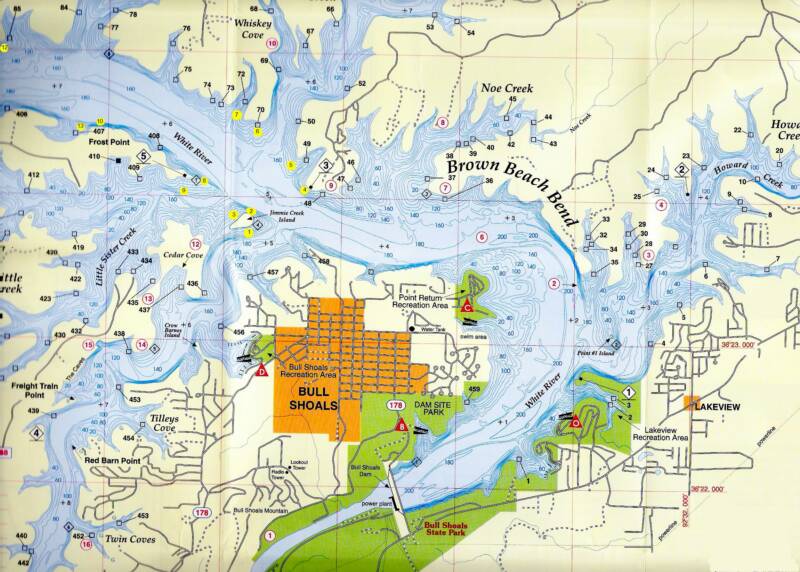
1. Wreck of the S.S. Minnow
Off the south side of Gilligan's Island. Swim south from the 2 willow trees to a depth of 20 feet. Turn east to the line and follow it to the wreck.
2. Destroyer Escort - 30 feet deep
East of Gilligan's Island. Near the clump of the willow trees swim east to a depth 20 feet, turn north to the line, follow the line to the wreck (careful of the live torpedo).
3. Iowa Farm - 35 feet deep
North side of Gilligan’s Island. About the center of island find the line at 20 feet depth. Follow it to the tractor and combine.
4. Troop Transport and Escort - 45 feet deep
Sunk during World War II by German U-Boat still has a live torpedo on the port bow. (Be careful! It could go off) There's a total of 3 boats. Near the Point 3 sign on the west side, find the line at a depth of 25 feet and follow to troop transport. Two escorts are just north of main boat.
5. Bus Stop - 55 feet deep
Wreck of the Bull Shoals Express. From east point at the entrance of Sister Creek, swim in a southwest direction to a depth of 25 feet. Follow the line to the bus.
6. Bermuda Triangle - 25 feet deep
Near the west side of Sister Creek, swim at 30 feet to line. Follow it to boats.
7. Spanish Wrecks - 20 feet deep
Just inside of cove find the line in 15 feet of water. Follow it to boats (any gold found must be turned in to dive shop.)
8. Key hole - 50 feet deep
Wall dive with large hole you can swim through. A second hole is about 30 feet deeper.
9. Rotor tiller - 25 feet deepA good search and recovery tool. We use it to teach lift bag techniques.
10. Frost Wall
A good wall dive.
13. Pirate Longboat Frost Point wall - 85 foot dive
Legend has it that the notorious pirate "Jeff the Bloodthirsty" hid his treasure along the shore here. Afterwards, he murdered all four of his crew then sank the bodies with the longboat in order to keep the location secret.
P1
P2
D3 Brown Beach Bend Point Rt. 0540396 Up 4027380
The lake was over 30 feet high when I dove this site just a couple of days after a very big storm. It was the hurricane that tore up Houston TX. and it would not be fair to rate the vis under this condition. However the site looks like a real neat dive. There are lots of big flat white rocks, over hangs and cliffs. A must do again when the lake is back to normal.
D4 Point Return Cliffs Rt. 0538284 Up 4027325
This site is an adventure to say the least. It is a lot like site P3 but with greater cliffs and over hangs and even some caverns. Plenty of depth. A great dive at any depth
P5
P6
P7

12
11
10. Frost Wall
A good wall dive.
11. Shear terror
A good wall dive with overhangs.
12. Alien landing - 20 feet to 40 feet
From the east Point 7 sign, swim in a westerly direction at a depth of 20 feet. Follow the line to the space ships. (Can you figure out what the writing says on the ships?)
13. Pirate Longboat Frost Point wall - 85 foot dive
Legend has it that the notorious pirate "Jeff the Bloodthirsty" hid his treasure along the shore here. Afterwards, he murdered all four of his crew then sank the bodies with the longboat in order to keep the location secret.
13
10
Bull Shoals Lake boat dock dive shop (870) 445-8354 The marina is (870) 445 4424

Click on a dive flags for
information about that site
Warning! Know your map! It may not be compatible with your GPS until you change your DATUM. There are two being used and your map and GPS are not necessarily the same in fact they are not if you have not changed it. For help go to the Index page look for DATUM.
